Release Date :
Reference Number :
SR 2020-24
Environmental Conditions and Quality is one of the six components of the United Nations Framework for the Development of Environment Statistics (FDES) 2013. This framework was adopted in the Cordillera Administrative Region (CAR) to come up with CAR Regional Compendium of Environment Statistics. Component 1 has three subcomponents, one of which is the Physical Conditions of the environment.
Physical Conditions
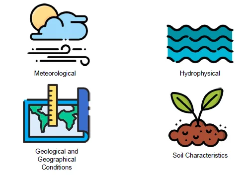
- The data compiled in this subcomponent suggest the status of the environment. These statistics provide information to program planners and policymakers on specific measures on effective and efficient environment-related programs and/or policies.
- Most of the data came from the Philippine Atmospheric, Geophysical and Astronomical Services Administration and the Department of Environment and Natural Resources.
ATMOSPHERE, CLIMATE, & WEATHER
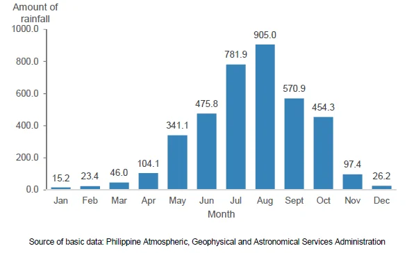
August has highest average rainfall with 905 mm
- CAR is known for its cool climate due to its high mean elevation. The provinces of Abra and Benguet fall within the first climatic type characterized by two distinct seasons, dry season from November to April and wet season for the rest of the year.
- Apayao, Mt. Province, Ifugao and Kalinga are within the third climatic type where seasons are not pronounced but are relatively dry from November to April and wet for the rest of the year.
- Some parts of Apayao is covered under the second and fourth climatic type where climate has no dry season but is marked with maximum rainfall in November and December and where climate has an even distribution of rainfall throughout the year.
- From 1981 to 2010, the average monthly rainfall showed that the largest amount of rainwater was poured during the month of August. Third quarter had the highest combined amount of rainfall with 2,257.8 mm, while first quarter had the lowest with 84.6 mm.
Figure 1. Average Monthly Rainfall, Baguio City Monitoring
Station: 1981 to 2010 (In millimeters)
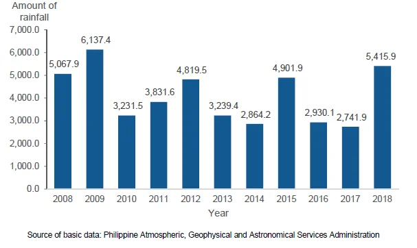
Annual average rainfall highest in 2009 with 6,137 mm
- From 2008 to 2018, the annual average rainfall recorded the highest in 2009 with 6,137.4 mm. On the other hand, the lowest amount of rainfall was reported in 2017 with 2,741.9 mm and a sharp increase in 2018 with 5,415.9 mm, almost twice the volume the previous year.
Figure 2. Annual Average Rainfall, Baguio Monitoring Station:
2008 to 2018 (In millimeters)
April is hottest month while January is coldest
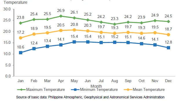
- Maximum monthly temperature data ranged from 23.3 degrees Celsius to 26.9 degrees Celsius. Based on the maximum temperature, the hottest months were March, April and May. Based on the minimum monthly temperature, the coldest months were December, January and February. Minimum temperature ranged from 10.6 degrees Celsius to 15.4 degrees Celsius for the period 2008 to 2018.
Figure 3. Monthly Maximum, Minimum and Mean Temperature
Recorded in Baguio City Monitoring Station: 2008 to 2018
(In degrees Celsius)
HYDROGRAPHICAL CHARACTERISTICS
Watershed in CAR covers 18,293 km2
- Cordillera is the only land-locked region in the Philippines. It hosts 13 major river basins with an estimated drainage area of 18,293 square kilometers and home to 46 major proclaimed forests and watersheds.
Table 1. Watershed Areas, CAR: 1999
- These river systems and watersheds are the source of water for irrigation of agricultural lands, for generating electricity and other economic purposes including household activities.
GEOLOGICAL & GEOGRAPHICAL INFORMATION
CAR’s land area covers 6.2% of the country
- CAR has six provinces – Abra, Apayao, Benguet, Ifugao, Kalinga and Mountain Province, and two cities – the chartered city of Baguio and the component city of Tabuk in Kalinga.
- The region’s total land area is 1,865,660 hectares or 6.2 percent of the total land area of the country. It has a mountainous topography characterized by towering peaks, plateaus and intermittent patches of valley. About 71 percent of the region’s land area has slopes of 30 degrees and above.
SOIL CHARACTERSTICS
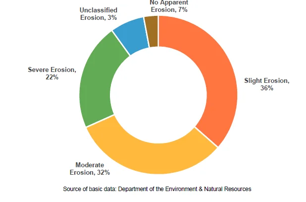
22% of land area of CAR susceptible to severe erosion
- The region is composed of various soil types dominated by mountain soil and clay loam which indicates the land suitability for cultivation. It comprises of 53 percent mountain soils, 17 percent clay loam, 9 percent clay, 4 percent loam and 17 percent other soil types.
- Human activities such as, land use conversion, deforestation and illegal logging, kaingin and other unsustainable farming practices, and poor land and water management have caused the quality of soil to decline contributing to soil degradation. UN Food and Agriculture Organization (FAO) defined soil degradation as the change in soil health status resulting in a diminished capacity to provide goods and services.
- Soil erosion was the most common type of soil degradation. Based on the data of DENR, majority of the land area of the region were susceptible in slight erosion (36%). There were also areas susceptible to moderate (32%) to severe erosion (22%).
Figure 4. Distribution of Areas Susceptible to Erosion by Class,
CAR: 2019
